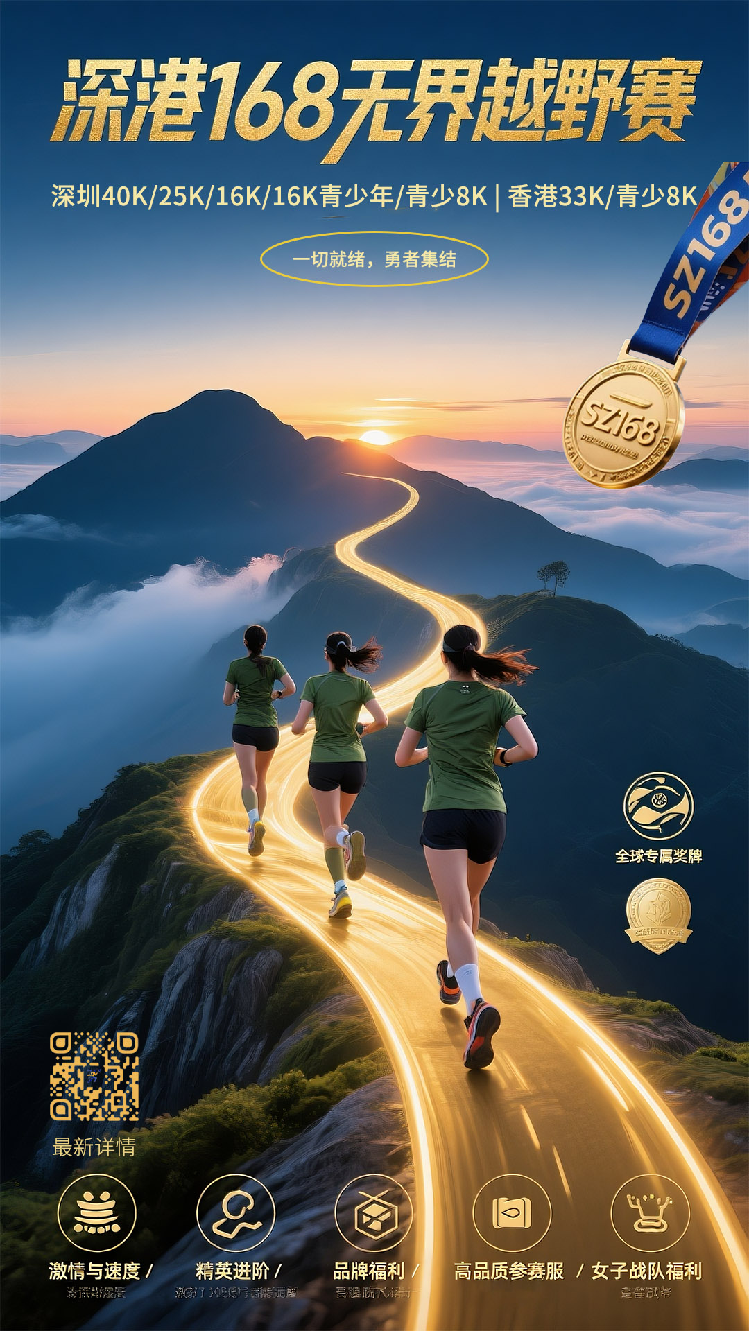
SZ-HK 168 · Boundless · Trail Run (with Youth Race)
The SZ168-HK Shenzhen-Hong Kong 168 Unbounded Cross-Country Race (and Youth Race) is a cross-country race launched by TOPSTAR for runners from mainland China, Hong Kong, and internationally. It is the industry's first cross-country race.
This cross-border race allows runners to experience both domestic and international courses, allowing cross-country enthusiasts from across China and even around the world to connect and collaborate on different trails, embodying the concept of unbounded Shenzhen and Hong Kong, unbounded mountains and wilderness, and unbounded runners.
All courses are professionally designed and certified by TOPSTAR, offering dual TPST & ITRA scoring. TPST points can be redeemed for future race fees or gear purchases.
The event starts/finishes at Wangtong Campground beneath Wutong Mountain, providing professional support including hydration, route guidance, medical rescue, and timing.
TOPSTAR is a global trail and marathon platform integrating 85% of runners' data worldwide, linking ITRA, UTMB, TPST, and marathon results. Its TPST scoring system adapts to China's terrain and offers performance analytics. Details: https://www.topstar.run/about-topstar
SZ168-HK Course Technical Description
Below is the route map for each group and a detailed introduction to each CP point.
Start/Finish: Wangtong Campground at Wutong Mountain base, featuring yurt-style tents amidst green peaks.
【40KM Group】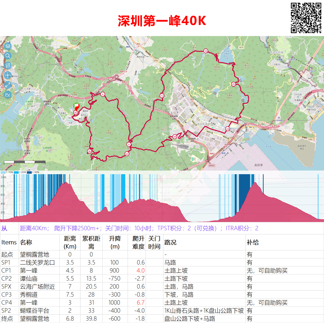
Download the gpx track file:2025 SZ168-HK-Shenzhen 40K
Summit Wutong Peak (Shenzhen’s highest) twice.
- Start→SP1: 3.5Km stone path/road (1Km gentle climb), ideal warm-up.
- SP1→CP1 (Summit): 4.5Km trail climb (900m ascent, gradient difficulty 4.0). Volunteers guide key turns. Self-service vending at summit (WeChat/Alipay).
- CP1→CP2 (Tanxian Temple): 5.5Km descent (900m drop). CP2 offers hydration.
- CP2→SPX (Cloud Sea Plaza): 7Km rolling terrain; photo spot.
- SPX→CP3 (Xiutong Trail): 7.5Km downhill; expedite in heat.
- CP3→CP4 (Summit): 3Km steep climb (810m ascent).
- CP4→SP2 (Butterfly Valley Platform): 1Km ridge descent (scenic views). Optional aid at SP2.
- SP2→Finish: 6.8Km paved descent; sprint or leisure pace.
【25KM Group】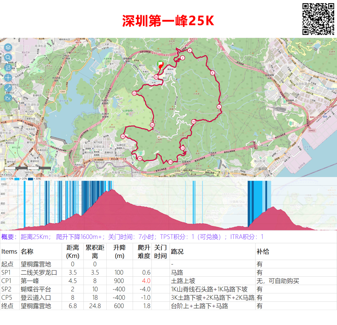
Download the gpx track file:2025 SZ168-HK-Shenzhen 25K
Matches 40KM to CP1, then:
- CP1→SP2: 1Km ridge descent (safety caution).
- SP2→CP5 (Dengyun Trail): 3Km drop + 5Km road.
- CP5→Finish: 1.5Km stairs → trail → 1.6Km road.
【16KM Group】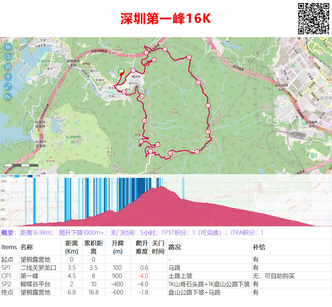
Download the gpx track file:2025 SZ168-HK-Shenzhen 16K
Matches 40KM to SP2, then identical finish segment.
【8KM Youth Group】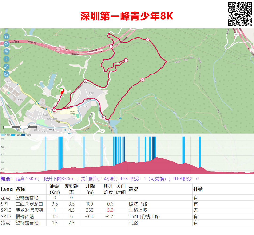
Download the gpx track file:2025 SZ168-HK-Shenzhen 8K
Blends road/trail for fitness test prep:
- Start→SP1.2 (Boundary Marker 34): 1Km climb (250m ascent).
- SP1.2→SP1.3 (Wutong Station): 1.5Km descent (slippery sections). Aid at SP1.3.
- SP1.3→Finish: 1.5Km road (avoid vehicles); 200m uphill finish.
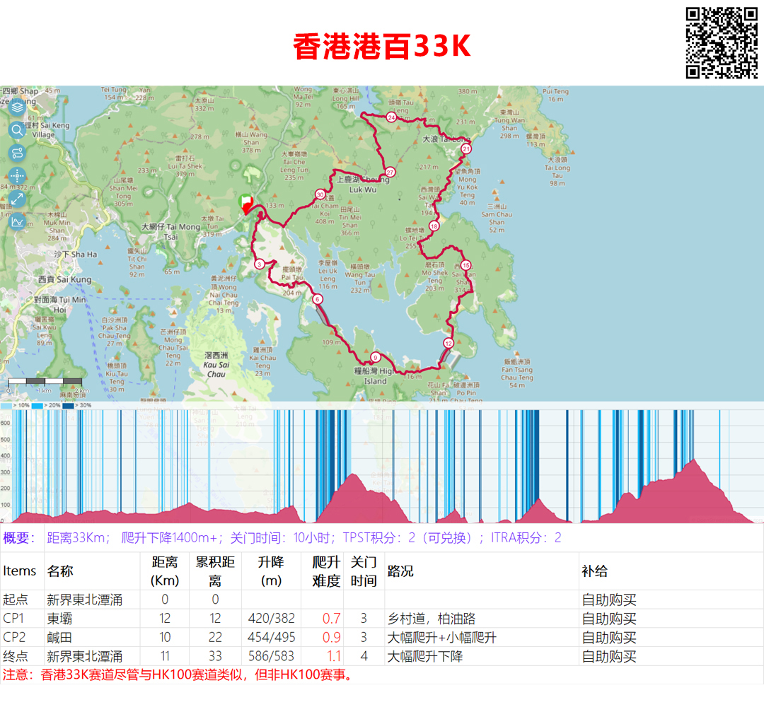
Download the gpx track file:2025 SZ168-HK-Hong Kong 33K
The Hong Kong 33km track is similar to the HK100 held in January 2026 (though not necessarily identical, as it's not the same event).
Both the start and finish are located in Pak Tam Chung, New Territories, Hong Kong, passing through two CP points: Tung Pa and Yan Tin. This race will have a pacer, but runners will need to purchase their own supplies.
The Hong Kong 33K Trail starts and finishes in Pak Tam Chung in the eastern New Territories of Hong Kong. It winds along the coast of the Sai Kung Peninsula, passing coastal paths, beaches, and ancient villages, and traversing hills and valleys before returning to the starting point at Pak Tam Chung. The entire trail covers approximately 33 kilometers, with over 1,400 meters of ascent, offering stunning views.
The first 800 meters are on paved road, before a sharp right bend leads to the Sheung Yiu Country Trail, a 5-kilometer classic Hong Kong winding countryside trail offering stunning views of the islands. Another 5 kilometers on paved road over the reservoir dam leads to the first control point, Tung Dam (total distance approximately 12 kilometers). Refuel here with water and other supplies. If you're not running fast, you can take in the views of the Hong Kong UNESCO Global Geopark!
From Control Point 1, there's a gentle climb and descent to Long Ke Beach, followed by another steep climb over Sai Wan Shan to Sai Wan Beach and Ham Tin Beach. You can see the sea and beaches of Hong Kong here, but please resist the urge to go surfing.
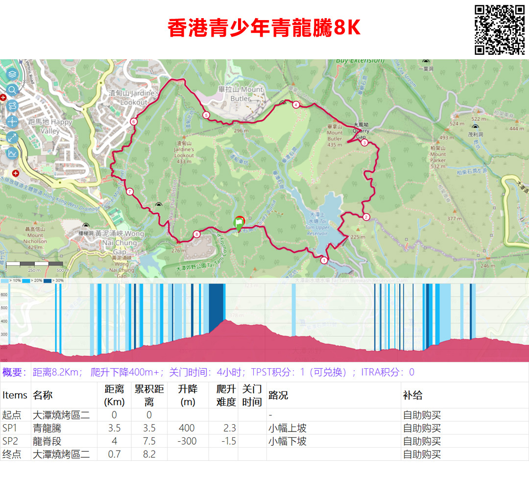
Download the gpx track file:2025 SZ168-HK-Hong Kong 8K
The Hong Kong 8K route starts and ends at Tai Tam BBQ Area 2, passing through Qinglongteng and Longji sections. There will also be a guide, and you can purchase supplies along the way.